
Path to Winter 2020-2021 : Looking at the ESNO Projections
Its about the time of year again where everyone is looking towards cooler weather after most of us at least on here have gotten tired of the hot weather. In this series this year we will weekly go over our path to winter 2020-2021 will be like. This week we will be discussing what the projections are of the current ESNO and if they hold true what it will mean for our region.
Current ESNO: Neutral

The current conditions indicate that we are in a neutral phase of the ESNO, we prior to this period were in an extended period of a weak el-nino. That is what we experienced over this past winter. What went wrong this past winter is that we had something called a southeast ridge that forced warmer than average air into the eastern half of the nation. Which resulted in much less snow, (if any) for most areas of the Mid-Atlantic.
Projected State of the ESNO-
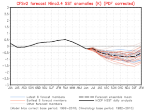
The main model I like to go by as it pertains to the ESNO projections is the CFS v2 because it seems over the years that it has been more accurate than not. The latest CFS V2 model run has us running into a weak la-nina period through the end of the year and through the winter.
What a typical weak la nina means for the eastern half of the united states during the winter:

On average the temperatures during the La nina years are colder than average, when the La-Nina is weak. Which could be a good sign for those that are cold and snow lovers in the east. And La-Nina’s are much wetter than average in the mid-Atlantic as well on average.

We here at Weather Advance will release our preliminary winter 2020-2021 outlook on Friday July/10/2020.
Greetings!!! I hope you guys are staying safe and I look forward to the winter 2020-2021 Outlook😃☕